A little while back I shared a post about how to get out and hike more. One of my suggestions was to find a local hiking group. I have to admit though that I had not yet been out with a group. I felt more comfortable hiking with my usual partner (my husband) or a friend that I've pre-vetted for hiking. However my usual hiking partner's schedules have been getting busier which means it was time for me to reach out to a local group.
A couple months ago I joined the Wanderung group, a Vancouver-based email callout system for hikers. When someone wants to head out on an adventure, they send an email callout to the mailing list. Wanderung also sends a weekly newsletter with lots of great details such as Leave No Trace tips, Avalanche awareness and recent trip reports.
There are usually a handful of callouts each weekend, with groups ranging from about 4 to 10 people. So far most of the callouts have headed to the North Shore mountains, an area I'm pretty comfortable snowshoeing by myself. This week however a callout came through for a hike into Manning Park, a provincial park about 2 hours east of Vancouver. I had already been thinking about heading that way on my own, and decided it made much more sense (and more safe!) to take a carload. I replied to the email right away and offered up my chauffeur services. I was headed to Manning Park, and more specifically to Windy Joe Lookout!
Hike Name: Windy Joe
Date: Saturday February 25
Location: Manning Park, BC
Approx. drive time: 2 hours
Distance: 10 mi. / 15 km
Elevation gain: 2000 ft / 600 m
Max. elevation: 6050 ft / 1850 m
Time on trail: 5.5 hours
I met the 4 other hikers at a pre-arranged rendezvous spot in the city at 8 a.m. We loaded into the car and quickly got down to the business of getting to know each other. One of the hikers had even brought delicious matcha white chocolate cookies to warm us all up to him. The time passed quickly with everyone sharing hiking stories and getting to know one another.
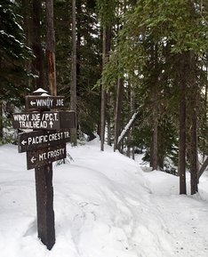
We made it to trailhead just after 10. It took a few minutes to get ourselves organized into our winter weather gear. Meanwhile a pair of large ravens watched the proceedings no doubt hoping we'd drop a treat or two.
We made it to trailhead just after 10. It took a few minutes to get ourselves organized into our winter weather gear. Meanwhile a pair of large ravens watched the proceedings no doubt hoping we'd drop a treat or two.
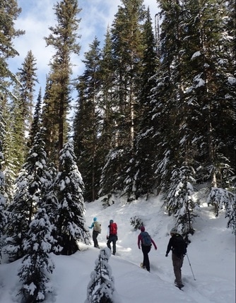 Heading up the road (Credit: @moveablefeast)
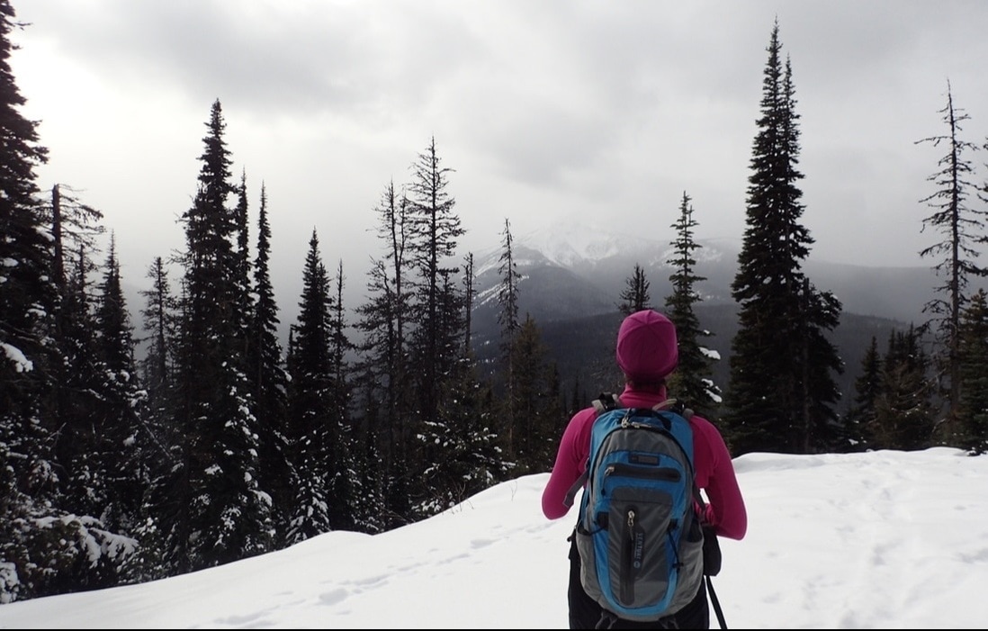
 We hit the trail right around 10:30. The first couple kilometres were a very gentle and flat wander along the Similkameen River, which has it's source in Manning Park. We took a couple short breaks to admire the snow and ice formations and also to do a bit of unfortunate snowshoe repair (trail lesson: zipties are an essential quick repair item!)
After two kilometres we reached a junction with an old forest service road. The Similkameen River trail continued to the left. We turned right, starting the slow climb upwards toward Windy Joe.
The trail had a pretty moderate grade, seeing as we were following an old forest service road. It never really got steep enough to bother putting up the heel lifts on our snowshoes.
The road took us through the forest, curving as it followed the flank of the mountain. We crossed a small stream flowing through a ravine and then started switchbacking properly up the mountain.
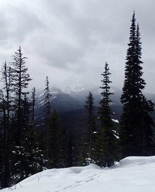 Frosty Mountain through the clouds
 There were kilometre markings on the trees but they didn't seem entirely accurate. However, somewhere around the 4 km mark we started to get openings in the trees with decent views of the nearby peaks. Our first viewpoint offered us a look down into the valley at Manning Park Resort and Blackwall Peak beyond.
Around the 5 km mark I started catching glimpses of a triangular peak to the south-west. We finally got a better look at it near the PCT junction and declared it to be Frosty Mountain, the highest and most prominent peak in the park.
We continued our gradual climb along the road. I started to get a bit more excited as we passed the 7 km marker. The trailhead sign had indicated the lookout was at 7.3 km. Those markers had to be misplaced though, otherwise that was the longest 0.3 km I've ever hiked! I'm sure it didn't help that the wind had come up, the clouds had dropped and we were hungry for our lunches!
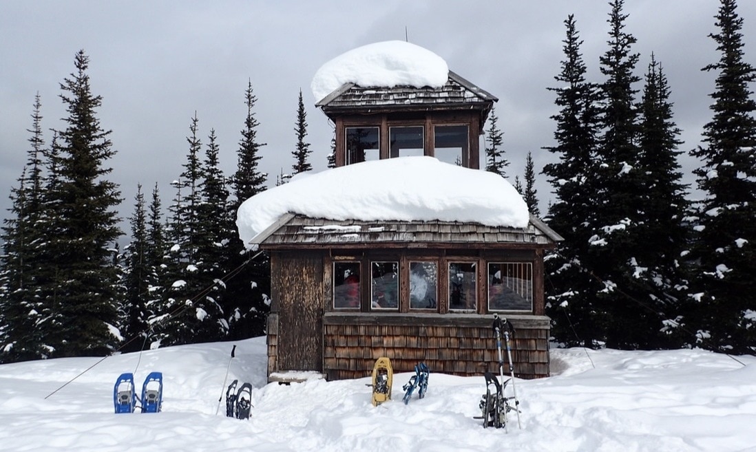
Sheltered in the lookout tower (Credit: @moveablefeast)
We reached the ridiculously cute lookout shelter just after 1 p.m. While far from warm, it was still nice to be sheltered from the wind and flurries of the summit. We settled in and devoured our lunches, then enjoyed a bit of time to explore the shelter and the surrounding views (which were lessening every minute as the latest snowstorm rolled in.)
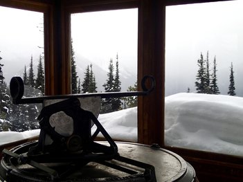
The shelter has a second story reached by a steep ladder and trap door. There were great interpretation signs featuring details about the lookout tower and pointing out the various peaks in view. There was also a wooden pedestal with a metal sighting device on it, which was used for determining the bearing of a forest fire.
After enjoying a good 45 minute rest in the shelter it was time to turn around and wander our way back down the trail.
It was a pretty quick trip back with fewer stops for breaks and an easy downward grade to follow. It seemed like we were wandering along the Similkameen River again in no time, and made it back to the trailhead about 2 hours after leaving the lookout.
All in all it was an incredibly successful trip. The five of us were a very cohesive hiking group and certainly enjoyed each other's company and conversation. While the weather wasn't perfect, it was still good enough, treating us to some sunshine in the morning, an occasional view and even an enjoyable light snowfall on the hike down. The lookout tower itself is a great destination with interesting views of the park. I will certainly do this trail again!
One last peek of Frosty Mountain (Credit: @moveablefeast)
